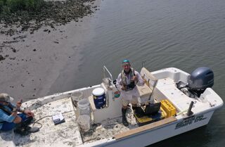
 Ben Aland is starting his field work flying drones to map oyster reefs along South Carolina shorelines. He is engaged in a full-time summer internship with the SC Department of Natural Resources to develop best practices for aerial drone data collection and post-processing to determine the spatial extent of oysters. This week he is flying drones and conducting ground truthing at low tide on Folly river. It's muddy work, but someone's gotta do it. Great job Ben!
Comments are closed.
|
AuthorErin Meyer-Gutbrod is an Assistant Professor at the University of South Carolina. Her lab researches human impacts to marine ecosysems. Archives
April 2024
Categories |
 RSS Feed
