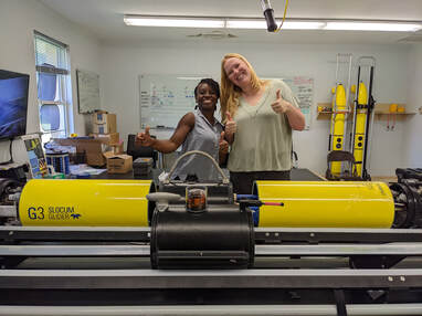
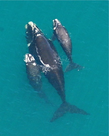
Real-time and archival acoustic detections of right whales in the Southeast US |
|
In a partnership between the University of South Carolina’s School of the Earth, Ocean and Environment and the University of Georgia’s Skidaway Institute of Oceanography, this project supports the integration of passive acoustic monitoring instrumentation in a Teledyne slocum glider for real-time acoustic detection of the critically endangered North Atlantic right whale. The low vehicle self-noise makes this an ideal system to monitor ambient noise and marine mammal calls and songs from 10 km away. We will use Low-Frequency Detection and Classification System (LFDCS) software to create spectrograms and use a pitch tracking algorithm to compare received calls against a call library for real-time species identification of right, fin, sei and humpback whales. Call reports and whale identifications will be sent to users onshore over satellite Iridium link at regular glider surface intervals to provide near real-time detections via WhaleMap and the Whale Alert app. We will conduct two separate 4-week missions to listen for south-bound right whales migrating towards the Southeast US calving grounds in early winter and to listen for north-bound mother-calf pairs migrating towards their springtime feeding grounds in the Northeast US. In addition to near real-time transmission of whale detections, acoustic and oceanographic data will be downloaded post-mission and processed to assess right whale migration behavior, environmental conditions and precision of real-time detection algorithms. This project work will serve two primary outcomes: 1) detect vocalizations and communicate data in near real-time to mariners using the Whale Alert app to reduce the risk of ship strikes in the Charleston and Savannah port areas; 2) assess changes in the timing and spatial extent of the winter migration corresponding to climate-driven shifts in foraging activities. We are extremely grateful for support from the Tides Foundation and a USC Aspire grant to fund this work.
Assessing the value of California oil platforms as artificial reefs |
|
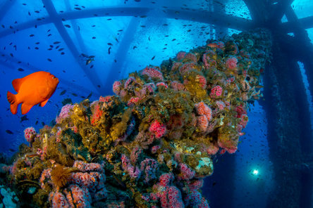
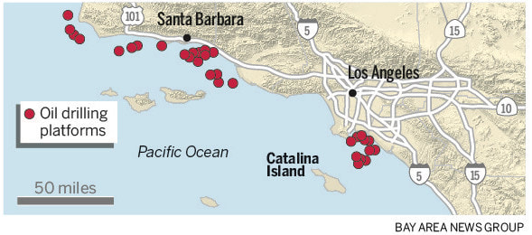
Off the coast of Southern California there are 27 oil and gas platforms ranging in depth from 15m to over 350m. As production declines and energy sources shift away from fossil fuels in the next two decades, the U.S. and the state of California must decide how to decommission these massive structures. Typically, after capping the fuel reservoirs, explosives are used to dislodge the jacket (the underwater frame) from the seafloor and all components of the platform are removed from the water and recycled. However, in 2010, Gov. Schwarzeneggar legalized decommissioning alternatives such as leaving the platform in place, removing the top portion for disposal onshore or removing the top and leaving it alongside the lower jacket. In these cost-saving alternatives, some or all of the infrastructure is left in the water, serving as an artificial reef. The hard, vertically extensive and structurally complex jackets disrupt expansive stretches of soft-bottom substrate and attract a diverse array of invertebrates and fish. Rockfish species in particular, such as overfished cowcod and bocaccio, prefer to live near the shelter of rocks, reefs and platforms, rather than exposed in the open ocean. Now governing bodies must decide whether to remove these platforms and return the channel back to a natural state or preserve these new biodiversity hot spots. To inform this decommissioning process, we will quantify the species composition, abundance and production of marine life on each platform as well as the connectivity between platforms and natural reefs. These analyses can be used to determine the relative contribution of each platform to commercially valuable fish stocks and marine biodiversity.
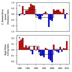
Climate-driven changes in prey impact right whale demographyConsidered one of the most endangered cetacean species, the North Atlantic right whale suffered declining abundance during the 1990s due to a high rate of anthropogenic mortality caused by ship strikes and fishing gear entanglement. Right whale reproductive rates are tightly coupled to the abundance of Calanus finmarchicus in the Gulf of Maine (GOM), their chief prey group. Given the endangered status of the right whale population, it is vital to determine how climate-associated changes in prey availability will affect this species in the future. Using matrix population models to study the dynamics of reproductive females moving between the reproductive stages of calving, lactating and resting, we explore multiple environmental proxies as potential predictors of annual calf production over a 3-decade period. Right whale births over this period are best predicted by temporally and spatially resolved observations of C. finmarchicus abundance data derived from Continuous Plankton Recorder (CPR) surveys of the GOM. Decadal-scale variability in right whale reproduction is largely driven by fluctuations in prey availability linked to ecosystem regime shifts associated with decadal-scale climate forcing from the Arctic and North Atlantic.
|
|
|
Forecasting right whale population growth under varied prey abundance and anthropogenic mortality ratesAbundant prey has led to a period of population growth at the start of the new millennium, with annual growth averaging 3% in the previous decade (2001-2010). However, a shift in right whale distribution and decline in calving rates in recent years indicate that the population may have shifted back to a regime of lower growth. Using capture-recapture techniques, I am analyzing the demographic dynamics of the right whale population and testing the role of prey abundance on species survival and breeding rates. To assess future viability, I build models to project right whale growth into the next century under a series of prey and anthropogenic mortality scenarios. While humans exhibit control over right whale mortality, fluctuations in fecundity driven by changes in prey abundance create a degree of unpredictability, resulting in limited control over the population’s fate.
|
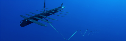
Wave- and solar-powered robots optimize fisheries acoustic stock assessment |
|
|
Technological and analytical innovations in the application of hydroacoustic techniques have advanced our knowledge of the size, type, abundance, distribution and behavior of fish and plankton, opening up a world that was previously inaccessible to marine biologists, oceanographers and fisheries scientists. Currently, ship-based acoustic surveys provide critical stock assessment data to the U.S. National Marine Fisheries Service (NMFS) for ecosystem-based management of marine living resources throughout the U.S. Exclusive Economic Zone (EEZ). However, due to the high cost of ship time, many stock assessment surveys are conducted on a yearly or biennial basis, often by a single ship over a time span of one or two months with no repetition of spatial coverage. New instrumentation for conducting fisheries acoustics research, such as the wave- and solar-powered Liquid Robotics Inc. (LRI) Wave Gliders, can transform stock assessment by providing increased spatial and temporal resolution monitoring at a comparable cost. In a collaboration between the Atkinson Center for a Sustainable Future and the Environmental Defense Fund, we are conducting a cost-benefit analysis of a fleet of robotic ocean sensing platforms compared to the biennial Joint U.S.-Canada Integrated Acoustic and Trawl Survey of Hake and Sardine.
|
